Tuesday 9 February 2016


                 Periyar National Park

Periyar National Park lies in the middle of a mountainous area of the Cardamom Hills. In the north and the east it is bounded by mountain ridges of over 1,700 m (5,600 ft) altitude and toward the west it expands into a 1,200 metres (3,900 ft) high plateau. From this level the altitude drops steeply to the deepest point of the reserve, the 100 metre valley of the Pamba River. The highest peak is the 2,019 m (6,624 ft) high Kottamalai. The Periyar and Pamba Rivers originate in the forests of the reserve. The other prominent peaks within the park are Pachayarmala, Vellimala, Sunderamala, Chokkampetti mala and Karimala. The topography consists of steep and rolling hills which are thickly wooded. The sanctuary surrounds Periyar Lake, a reservoir measuring 26 km2 (10 sq mi) which was formed when the Mullaperiyar Dam was erected in 1895. The reservoir and the Periyar River meander around the contours of the wooded hills, providing a permanent source of water for the local wildlife.

The park is made up of tropical evergreen and moist deciduous forests, grasslands, stands of eucalyptus, and lake and river ecosystems. There are many hundreds of flowering plant taxa, including about 171 species of grass and 140 species of orchids. The grasses are found in the open grasslands found on the edges of the water body where fire resistant vegetation grows and dense grasses like elephant grass are found. This is the common dining hall of various herbivores.
The forests contain deciduous and semi evergreen trees like teak, rosewoods, terminalias, sandalwoods, jacarandas, mangoes, jamun, tamarind, banyans, sacred fig, plumerias, royal poinciana, kino tree, bamboos, and the only South Indian conifer, Nageia wallichiana. The medicinal gloriosa lily grows in the park. The endemic flora includes Habenaria periyarensis and Syzygium periyarensis.
The park is surrounded by agricultural regions, especially plantations of such crops as tea, cardamom, and coffee.


Periyar National Park lies in the middle of a mountainous area of the Cardamom Hills. In the north and the east it is bounded by mountain ridges of over 1,700 m (5,600 ft) altitude and toward the west it expands into a 1,200 metres (3,900 ft) high plateau. From this level the altitude drops steeply to the deepest point of the reserve, the 100 metre valley of the Pamba River. The highest peak is the 2,019 m (6,624 ft) high Kottamalai. The Periyar and Pamba Rivers originate in the forests of the reserve. The other prominent peaks within the park are Pachayarmala, Vellimala, Sunderamala, Chokkampetti mala and Karimala. The topography consists of steep and rolling hills which are thickly wooded. The sanctuary surrounds Periyar Lake, a reservoir measuring 26 km2 (10 sq mi) which was formed when the Mullaperiyar Dam was erected in 1895. The reservoir and the Periyar River meander around the contours of the wooded hills, providing a permanent source of water for the local wildlife.


            Vedanthangal Bird Sanctuary

Vedanthangal is the oldest water bird sanctuary in the country. Vedanthangal in Tamil language means 'hamlet of the hunter'. This area was a favourite hunting spot of the local landlords in the early 18th century. The region attracted a variety of birds because it was dotted with small lakes that acted as feeding grounds for the birds. Realising its ornithological importance, the British government undertook steps to develop Vedanthangal into a bird sanctuary as early as 1798. This was established in 1858 by the order of the Collector of Chingleput. The Vedanthangal lake bird sanctuary has a tradition of the people actively protecting birds coming to the area since time immemorial. The local people understood the relationship between birds and the productivity of their crops even before the concept of wildlife conservation came into vogue. They knew that the bird droppings in the water created guano which acted as fertilizer.

 Towards the end of the 18th century local villagers complained to the collector of Chengalpet Lionel Palace, about the British soldiers shooting the birds. They demanded and obtained a 'Cowle' from the collector (Mr Place, Collector of Chingleput 1796-1798) to protect the birds. In 1936 the collector officially recognized the lake as a sanctuary. In 1962 it was given the legal status of reserved forest under the Madras Forest Act. Several accounts of the sanctuary were published in the mid-19th century. In 1936, the park was notified as a sanctuary, and in 1962, the Madras Forest Act legally accorded the status of a reserve forest to Vedanthangal. Ten years later, the place was declared as a wildlife sanctuary.Vedanthangal lake is situated 122 m above sea level. It supplies water to 250 acres of agricultural land around the area. The west and south sides of the lake are bordered by a long bund, whereas the northern and eastern sides extend to the agricultural lands. Input of water into this lake is through four small canals. Maximum depth of the lake is 5 metres. The area receives an average annual rainfall of 10 mm, mostly from the north-east monsoon.


Vedanthangal birds sanctuary is one of the smallest and oldest in the country with a unique history. The local people have been protecting the sanctuary for centuries now because they have realized that the bird droppings falling into the tank increases nitrogen content of the water and when used to irrigate crop increases the yield greatly and saves the cost of fertilizers. As far back as 1798, the village folk convinced the authorities to give protection to the birds of the 30 ha. area of the Vedanthangal tank. Around 30000 birds come every season even though the area is just 30 ha It then attracts multitudes of herons, egrets, storks, ibises and spoon bills. If the monsoon is heavy, these trees can be partially submerged. Despite its compact size, Vedanthangal is worth a visit, especially between October and January, for the experience of seeing nesting birds in the thousand within close range.


                            Dudhwa National Park

The Dudhwa Tiger Reserve is a protected area in Uttar Pradesh that stretches mainly across the Lakhimpur Kheri and Bahraich districts and comprises the Dudhwa National Park, Kishanpur Wildlife Sanctuary and Katarniaghat Wildlife Sanctuary. It covers an area of 1,284.3 km (495.9 sq mi) and includes three large forest fragments amidst the matrix dominated by agriculture. It shares the north-eastern boundary with Nepal, which is defined to a large extent by the Mohana River. The area is a vast alluvial floodplain traversed by numerous rivers and streams flowing in south-easterly direction. It ranges in altitude from 110 to 185 m (361 to 607 ft).


Dudhwa National Park is great paradise near nepal border. Dudhwa national park residing the areas of Lakhimpur & Kheri district of Uttar Pradesh, lying adjacent to the Indo-Nepal border bringing together two most incredible sanctuaries of the area namely, Kishanpur and Katerniaghat Wildlife Sanctuaries to represent the excellent natural forests and greenery along the Terai region. Quite impressively, the northern boundary of the park is being constituted by the Mohana River flowing along the Indo-Nepal border whilst the Southern boundary is formed by the river Suheli. The Kishanpur Sanctuary lies in the Lakhimpur- Kheri and Shahajahanpur districts in Uttar Pradesh. Spreading across an expanse of 811 sq km beholding the nature lovers with marshes, grasslands and dense forests, the area is actually meant for tremendous counts of Swamp Deer and Tigers species. The area of the Park is composed of a vast alluvial plain along the tributaries of Mohana and Suheli, interspersed with numerous rivulets, lakes and pools. The rich and extremely fertile Indo-Gangetic plains support a flamboyant growth of forests diversity of fauna. The park has some of the best forests of 'Sal' tree in the world, amongst other flora; and is a virtual unexplored paradise for nature lovers, wildlife enthusiasts and bird watchers.


Dudhwa attracts the visitors with its two core area as Dudhwa National Park and Kishanpur Wildlife Sanctuary which are separated by each other with an area of 15 kms agricultural land. Unlike other celebrity parks of India like Jim Corbett National Park, Kaziranga National Park, Bandhavgarh National Park etc, the uncommercialized ambience of this park makes it an ideal habitat for the wild creatures to find nature's serenity & comfortability in a more natural way. About Us - Generally people think this site official website of Dudhwa tiger reserve or Dudhwa national park. But, it is not true this site private travel company's website, This belongs to such an individuals who deal in online Dudhwa safari booking, online Dudhwa jeep safari booking, online Dudhwa forest lodge booking, online Dudhwa elephant safari booking, online Dudhwa safari booking, online Dudhwa jungle tour packages booking, online Dudhwa forest resort booking, Dudhwa online jeep rental, online Dudhwa motel booking, Website of Dudhwa national park uttar pradesh india, Dudhwa Tiger Reserve, online Dudhwa jungle safari booking, Dudhwa national park booking, Dudhwa tiger reserve accommodation, online dudhwa resorts, hotels booking, online Dudhwa forest rest house booking and Online Dudhwa national park packages booking. We are bound to follow the same rules and regulations which are directed by The Dudhwa Tiger Reserve & Uttar Pradesh Government. The source of the data & information relating to Dudhwa national park is the official website of Dudhwa tiger reserve.

Best Time to Visit Dudhwa National Park

The best time to visit Dudhwa National Park is between November and May. The park remains open to public from 15th November to 15th June, though the months of May and June are a little too hot for comfort. While visiting the Park during winter you must remember to take woolen clothes as it can get pretty chilly, particularly between December to February


                Kishtwar National Park

The National Park encompasses the catchments of Kiar, Nath and Kibar Nalas, all of which drain south-west into Marwa River which joins the Chenab River just above Kishtwar Town. The terrain is generally rugged and steep, with narrow valleys bounded by high ridges opening in their upper glacial parts. The area lies in the Central Crystalline belt of the Great Himalayas. Rocks are strongly folded in places and composed mainly of granite, gneiss and schist, with the occasional bed of marble. The shallow, slightly alkaline soils are mostly alluvial with gravel deposits (Kurt,1976;Bacha, 1986).There are permanent settlements but some 1,115 families of nomadic graziers, with 25,000 head of livestock, and an unspecified number of families from nearby villages, with 10,000 head, have grazing rights in the national park. Some agriculture is practised in peripheral areas. (Bacha, 1986).

Based on revised classification of Champion and Seth (1968), some 13 vegetation types are represented (Bacha,1986). In general, silver fir 'Abies pindrow' and spruce 'Picea wallichian', mixed with cedar Cedrus deodar and blue pine Pinus griffithii are predominant from 2,400m to 3,000m. Notable is the small expanse of chilgoza pine Pinus geradiana in the Dachan Range. At lower altitudes (1,700-2,400m) occur nearly pure stands of cedar and blue pine, and moist temperate deciduous forest, represented by horsechestnut, Aesculus indica, walnut Juglans regia, maple, Acer spp. poplar, Populus ciliata, hazel Corylus cornutam bird cherry Pasus corfnuta, ash Fraxinus cornuta and yew Taxus wallichiana. The sub-alpine zone, from 3,000m to the tree line at 3,700m, supports mostly silver fir and birch Betula utilis forest and this merges with birch -rhododendron Rhododendron campanulatum scrub, above which is alpine pasture. Among the animals that make their home here include the Himalayan snowcock and the brown bear.


The influence of the monsoon is weak. Mean annual rainfall at palmar and Sirshi (1,761 m), located near the periphery of the national park, is 827 mm and 741 mm, respectively, precipitation is maximal and in excess of 100 mm per month in March and April, and again in July and August.Most snow fall in December and January when the whole area becomes snowbound. Mean maximum and minimum temperatures recorded at Sirshi are 130 and -70 in January and 350c and 110c in July respectively (Kurt, 1976;Bacha,1986).

                             Pin Valley National Park

The park is located in the desert habitat of the Spiti Valley, within the Cold Desert Biosphere Reserve, in the Himalayas region. Spreading south of Dhankar Gompa near the Tibetan border, the park marks the border between the formerly separate districts of Lahaul and Spiti. The elevation of the park ranges from about 3,500 metres (11,500 ft) near Ka Dogri to more than 6,000 metres (20,000 ft) at its highest point. 

 Some plants within the park's alpine habitats have significant medicinal properties. Twenty two rare and endangered medicinal plant species, have been discovered in and around Pin Valley National Park, which are distributed over 10 different habitat types. Aconitum  rotundifolium, Arnebia euchroma, Ephedra gerardiana, Ferula jaeschkeana, Hyoscymus niger are the threatened but medicinally important plants occur in this national park. Because of the park's high altitude and extreme temperatures, the vegetation density is sparse, consisting mostly of alpine trees and groves of Himalayan cedar (Cedrus deodara). In summer, rare birds such as the Himalayan snowcock, chukar partridge, snow partridge and snowfinch flourish in the park . 


Steeped in historical and present day Buddhist Tibetan culture, the area has many Tibetan Buddhist influences, evident architecturally in monasteries and stupas, and in the daily living of its residents and lamas. Pin Valley National Park was established by India in 1987.Pin Valley National Park is a National park of India located within the Lahaul and Spiti district, in the state of Himachal Pradesh, in far Northern India.

                   Navegaon National Park

Navegaon National Park is a national park located in the Gondia district of Maharashtra, India. Navegaon, a popular forest resort in the Vidarbha region, the easternmost part of Maharashtra, was built in the 18th century. The picturesque lake set amidst lush green hills at Navegaon, has a watch-tower beside it. One can get a bird's eye view of the surrounding forest and marvel at the exciting wildlife from the watch-tower which consists of a deer park, Dr. Salem bird sanctuary, and three exotic gardens. The Dr Salim Ali Bird Sanctuary, Navegaon is home to almost 60% of the bird species found in entire Maharashtra. Every winter, flocks of beautiful migratory birds visit the lake—a rare treat for the eyes. The national park has diverse type of vegetation ranging from dry mixed forest to moist forest. The forest type is 5 A/C3.

 Southern tropical dry deciduous forest. The most unique experiences of the Navegaon National Park that you will have are going on a jungle safari, staying in a tree top house and riding a sail boat in the lake.  It is located in the eastern part of Maharashtra state and covers an area of 133.78 km2. It has great importance from nature conservation point of view. It is indeed nature priceless assets and beckons one and all to enjoy its picturesque landscape, its pure and fresh air. It has got immense potentials from biodiversity conservation point of view.One can also join the jungle safari and stroll through the beautiful forest, crossing paths with leopards, sloth bears, gaurs, sambars, chitals and langoors. Staying in the unique tree-top house, riding a power or sail boat on the lake, are thrilling pastimes. Nearly 50,000 tourists visits this tourist complex annually. Places of interest around the national park are Nagzira Wildlife Sanctuary (60 km), Itiadoh Dam (20 km), Tibetan Camp at Gothangaon (15 km) and Pratapgad (15 km).


 This far-sighted consort of king Dalpatshah, chose these hardy sons of the soil, the Kohalis, to take up this venture. So, in the year 1300 A.D., the great exodus of the Kohalis began in right earnest. They were awarded large farming tracts as incentives, for constructing tanks, canals and waste weirs for storage and supply of water. They were also conferred with the title of 'PATEL' or PATIL'. As the zamindari and malguzari system was not in vogue, these Patels/Patils were entrusted with the job of collecting agricultural cess. Agricultural development being the main item on the agenda of the queen, two brothers viz. Kolhu and Chimna Patil of the Kohali community, were delegated with the task of constructing a lake (at Navegaon) in the year 1300. From here begins the saga of Madhaorao Patil’s ancestors Kolhu & Chimna, scions of Bija Patil Dongarwar. This diligent brother-duo, first made alternate arrangements to resettle the displaced inhabitants of 12 villages, that were going to be affected by the construction of lake and that is today’s Navegaon village. Hundreds of labourers were employed in construction of the lake and dam-wall. Mode of payment to labourers was in the form of conches and mollusc shells. Herds of cattle were pressed into service, to trample the freshy excavated and water-sprinkled soil dumped for the dam-wall, to provide solidity. Water stored in the reservoir, would be provided free of cost to all farmers.


After completing the dam, to express their gratitude to God, a fish of the ‘Wadis’ species was caught and adored with 30 Tolas of Gold ornaments and again released in the tank. This fish was reported to be sighted for several years, resplendent in all its ornaments. While constructing the dam, a temple of God Hanuman was simultaneously constructed. Here, the lookers on the construction site, first paid obeisance daily, before commencing the work. For accumulation of water, a 200 yard sloping waste weir was built which also facilitate Eel fish from the back-waters of the sea to enter the lake by rivulets for spawning. The Govt took over the management of this dam in 1951. They dismantled this waste-weir and reconstructed another waste-weir in the form of water-fall.


Monday 8 February 2016

Hii Everyone,
                    I would got some exclusive information about Nanda Devi National Park. Nanda Devi and Valley of Flowers national parks . National Park is encompassed in the Nanda Devi Biosphere Reserve totaling a protected area .The entire Nanda Devi Biosphere Reserve lies within the Western Himalayas Endemic Bird Area (EBA). Seven restricted-range bird. 

                Nanda Devi National Park


Situated at the base of Nanda Devi peak, India’s second highest peak; the Nanda Devi National Park is situated in the higher ranges of Himalaya in Chamoli district of Uttarakhand in North India. Designated as the World Heritage Site, the park has unique topography and supports several habitats, species and eco-systems. The Nanda Devi basin was declared a sanctuary in1939. In the 1982, an area of 630.33 sq km was added and it was declared a national park, which now forms the core zone of Nanda Devi Biosphere Reserve. The park was declared a World Heritage Site in the 1988 along with the Valley of Flowers. Besides the Himalayan valleys and lush greenery, visitors can see animals including snow leopards, Himalayan black-bear, Himalayan musk deer, Himalayan tahr and many more. The park is also an ideal place for bird watchers. About 100 species of birds have made the park their home. Birds including orange-flanked bush robin, Indian tree pipit, blue-fronted redstart are seen more often. The park is also home to several species of butterflies, 312 species of flowers including juniper and alpine vegetation.
The park is divided into two parts — Inner and Outer. The Upper Rishi Valley, often referred to as the Inner Sanctuary is fed by Changbang, North Rishi and North Nanda Devi glaciers. The Trisuli and Ramani glaciers are features of the Outer Sanctuary.

Trekking is the most popular activity in the national park. The trek begins from the Lata village to Dharasi (4250 mt) – the highest point of the region. In 1982, access to trekkers was banned to protect the biodiversity. However recently, tourists in small numbers are allowed to visit the park.
There are very few accommodation options near the national park. Visitors can choose to stay in the hotels at Joshimath or else at Badrinath. There are hardly any restaurants within the park. It is advisable to carry food hamper and water.


The best time to visit the national park is during the months of April and October. During these months, the park is not covered under snow.
Hiii Everyone,
                   I would got some exclusive information about Gobindsagar Wildlife Sanctuary . To maintain the level of water, the flow of river Beas was channelized to Gobind Sagar by the Beas-Sutlej link which was accomplished in 1976.


             Gobindsagar Wildlife Sanctuary

Gobind Sagar reservoir in Bilaspur with its 56 km length and nearly 3 km breadth.It offers a variety of watersports activities in close collaboration with the Directorate tourism and Civil Aviation and Directorate of Mountaineering and Allied Sports.  River rafting or white water rafting, as it is also called, is swiftly making Bilaspur a focus for this scintillating sport. For a torrent of adrenaline to gush through every vein and surge cover every muscle, one can race over the rapids of river – Sutlej, right from Rampur to Bilaspur through serpentine path in deep gorges, placid mountains, green alpine meadows and thick forests, all forming an immense spectrum. Non swimmers and novice can also have this thrilling experience in an inflatable rubber dinghy, on some of the gentler rapids.Due to fluctuating level of Lake here, the watersports are mainly confined to half of the year i.e. August to January. During this period the activities include swimming, surfing, water-skiing, kayaking, rowing, canoeing, white water river rafting. Courses are conducted at three levels – beginners, intermediate and advance. For this Tourism Department of Himachal Pradesh has constructed a huge Water Sports Complex in Luhnoo Ground,Bilaspur with all the boarding, lodging and equipment facilities.
 Gobind Sagar is a man-made reservoir situated in Bilaspur District, Himachal Pradesh. It is formed by the Bhakra Dam.
The reservoir is on the river Sutlej. The dam has been named in honour of Guru Gobind Singh, the tenth Sikh guru. One of the world's highest gravity dams, the Bhakra dam rises nearly 225.5 m above its lowest foundations.


 Under the supervision of the American dam-builder, Harvey Slocum, work began in the year of 1955 and was completed in 1962. To maintain the level of water, the flow of river Beas was channelized to Gobind Sagar by the Beas-Sutlej link which was accomplished in 1976.
Hii Everyone,
                   I got some information about Blackbuck National Park,Blackbuck National Park at Velavadar is situated in the Bhavnagar District of Gujarat state, India. Established in 1976 in the Bhal region of Saurashtra,

                 Blackbuck National Park 


Though the park is open throughout the year, the period between monsoon and winter (normally, mid-June to the end of March) is recommended. The best time to visit is from December to March as many species of migratory birds including three species of harriers, the lesser florican, eagles and waders. Bhavnagar Airport is connected with Mumbai by daily flights. The closest international airport is Sardar Vallabhbhai Patel at 153 km by road. The closest railway station is at the town of Dhola, which is about 50 km from the park. The ancient town of Vallabhi is about 30 km away.

The park has a bungalow operated by the government forest department where a stay can be arranged by prior booking. Right next to the park, there is a private lodge as well.Established in 1976 in the Bhal region of Saurashtra, the park is located around 42 km from the district headquarters city of Bhavnagar. Hugging the coasts of the Gulf of Khambhat on the south, it is spread over an area of 34.08 km2, which was primarily a "vidi" (grassland) of the maharaja of the princely state of Bhavnagar for hunting the blackbucks with his famous hunting cheetahs. On the northern side, it is surrounded by wastelands and agriculture fields. The national park has been classified as 4B Gujarat-Rajwada biotic province of semi-arid bio geographical zone.


Flat land, dry grasses and herds of antelope have always attracted visitors to this park which has a grassland ecosystem. Successful conservation programs for the blackbuck, wolf and lesser florican (a bustard) are ongoing. Considered to be an endemic Indian species, the lesser florican, which once lived throughout the country, has become endangered in recent decades. Today, the largest population is in this park. Local wolf numbers are increasing, as are striped hyena, with sightings quite frequent during daylight in winter 2012-2013.
Hiii Everyone,
                    I would got some information about Tadoba National Park.Tadoba national park is open for visitors from 15-Oct to 30-June every season. Despite of this, limited safari is possible from 01-Oct on current booking basis. Tadoba national park remains Full-day CLOSED for visitors on every Tuesday. Unlike Bandhavgarh, Kanha national park, Pench national parks, here safari charges are some for Indian and foreigner visitors.

                                              Tadoba National Park
 
Tadoba Andhari Tiger Reserve is one of the finest & largest National Parks in Maharashtra. It is one of India’s 47 project tiger reserves existing in India. It lies in Chandrapur district of Maharashtra state. This beautiful wild paradise is situated 45 km close to Chandrapur District of central Indian State Maharashtra, and is about 150 km from Nagpur city which is the nearest airport for visiting Tadoba national park. Its name 'Tadoba' is derived from the name of God "Tadoba" or "Taru" whiich is praised by local tribal people, whereas "Andhari" is derived from name of Andhari river. It is believed that Taru was the village chief who was killed in an fierce encounter with Tiger and thus a shrine was made in remembrance of God Taru.

This region was predominantly ruled by Gond tribes which had their own Kingdom in large area of Central India. Their descendents are still can be seen in local villages. Tadoba national park is open for visitors from 15-Oct to 30-June every season. Despite of this, limited safari is possible from 01-Oct on current booking basis. Tadoba national park remains Full-day CLOSED for visitors on every Tuesday. Unlike Bandhavgarh, Kanha national park, Pench national parks, here safari charges are some for Indian and foreigner visitors. Online safari booking is available for tourists. For traveling from Nagpur to Tadoba national park, we offers Tadoba Car Rental service with luxury cabs to undertake tours. Vegetation of Tadoba forest is of Southern tropical dry deciduous type which is spread on around 626 sq. km. Teak is the prominent tree species in Tadoba forest. Their is few lakes in Tadoba forest area which ensures rich in water resources for the park and nestles rich aquatic life. Among them Irai lake is one well known among tourists. It remains filled with water throughout the year, even in extreme summers. These lakes are also the prime residential place for marsh crocodiles, those were knowing once to spread in across Maharashtra.


Major part of this forest is thrived in hilly area; it covers the Chimur Hills, and Andhari sanctuary covers Moharali & Kolsa ranges, so many hillocks, terrains provide shelter to wild animals, since it is considered that this park has a great accessibility & sighting of many wild beasts, wild-lovers from many parts of the country & world arrives here. Being popular gradually for its dense forest area, smooth meadows and deep valleys and moreover to all is the good sight-seeing of tiger despite being low numbers, the park has a great potential & atmosphere to stabilize more numbers of tigers with extending park area
Hiii Everyone,
                   I would got some information about Hemis National Park.


                      Hemis National Park

The park houses numerous Tibetan gompas and holy chortens within its boundaries. These include the famous 400-year-old Hemis Monastery. Hemis was a destination and via point on the silk routes of Tibet. Over 1,600 people live inside the park presently, with a large number of tourists and pilgrims visiting during the Hemis Tsechu festival.This region is in the rain shadow of the Himalayas, and does not receive much precipitation. Hence, dry forests of juniper, Populus - Salix forests, subalpine dry birch - fir are present at lower altitudes. You will find alpine and steppe trees predominantly at Hemis High National Park. These trees and shrubs are spread across the valley bottoms. Since the upper mountain slopes are moist, this area is characterized by alpine vegetation including: Anemone,Gentiana, Thallctrwn, Lloydia, Veronica, Delphinum, Care.x and Kobresia. The other parts of the park support steppe vegetation which is dominated by Caragana, Artemisia, Stachys, and Ephedra, present along the lower river courses.

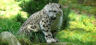
Hemis National Park  is a high altitude national park in the eastern Ladakh region of the state of Jammu and Kashmir in India. World famous for being the best place to see the snow leopard in the wild, it is believed to have the highest density of snow leopards of any protected area in the world. It is the only national park in India north of the Himalayas, the largest notified protected area in India (and thus the largest national park of India), and is the second largest contiguous protected area after the Nanda Devi Biosphere Reserve and surrounding protected areas. The park is home to a number of species of endangered mammals including the snow leopard. Hemis National Park is India's only protected area inside the Palearctic ecozone, outside the Changthang Wildlife Sanctuary northeast of Hemis, and the proposed Tso Lhamo Cold Desert Conservation Area in North Sikkim.


The park houses numerous Tibetan gompas and holy chortens within its boundaries. These include the famous 400-year-old Hemis Monastery. Hemis was a destination and via point on the silk routes of Tibet. Over 1,600 people live inside the park presently, with a large number of tourists and pilgrims visiting during the Hemis Tsechu festival.

The Hemis High Altitude National Park that extends over 600 sq. km. is named after the famous monastery, Hemis gompa that is situated 40 km. southeast of Leh. Located on the west bank of the Indus River, it comprises the catchments of Markha, Rumbak and Sumdah nalas. It is known for some rare species like the bharal and the snow leopard. Hemis has in fact been identified as a snow leopard reserve under a project launched by the Central Government aimed at conserving the species, its prey base and its fragile mountainous home. - See more at: http://www.sanctuaryasia.com/travel/wildlife-destinations/jammu-and-kashmir/hemis-high-altitude-national-park.html#sthash.F434cuvk.dpuf
Hiii Everyone,
Dachigam also drop abysmally to -100C. Between late November and early February, the area is entirely snowbound. The best time to visit is May to November. In November, you can see hangul stags with their magnificent antlers fully grown. - See more at: http://www.sanctuaryasia.com/travel/wildlife-destinations/jammu-and-kashmir/dachigam-national-park.html#sthash.93qZDobB.dpuf
                   I would got some information about Dachigam National Park.
Dachigam also drop abysmally to -100C. Between late November and early February, the area is entirely snowbound. The best time to visit is May to November. In November, you can see hangul stags with their magnificent antlers fully grown. - See more at: http://www.sanctuaryasia.com/travel/wildlife-destinations/jammu-and-kashmir/dachigam-national-park.html#sthash.93qZDobB.dpuf

Dachigam also drop abysmally to -100C. Between late November and early February, the area is entirely snowbound. The best time to visit is May to November. In November, you can see hangul stags with their magnificent antlers fully grown. - See more at: http://www.sanctuaryasia.com/travel/wildlife-destinations/jammu-and-kashmir/dachigam-national-park.html#sthash.93qZDobB.dpuf

Dachigam also drop abysmally to -100C. Between late November and early February, the area is entirely snowbound. The best time to visit is May to November. In November, you can see hangul stags with their magnificent antlers fully grown. - See more at: http://www.sanctuaryasia.com/travel/wildlife-destinations/jammu-and-kashmir/dachigam-national-park.html#sthash.93qZDobB.dpuf
                                   Dachigam National Park

Dachigam National Park sets in unblemished bewitching scenic surrounds of the northern Indian state of Jammu and Kashmir. The national park is located at a distance of 22km from Srinagar. The park is enclosed by two ridges with a great variety of flora and fauna. The splendid forests of Dachigam are divided into two parts . Upper and Lower Dachigam. The mountainsides below the tree line are heavily wooded. Most of this coniferous forest consists of broad leaf species. Interspersed between these are alpine pastures, meadows, waterfalls and scrub vegetation with deep gullies, locally known as Nars, running down the mountain face. Most of the grasslands and meadows, except in the harsh winters, are covered with brightly coloured flowers.

Located high among its interiors is the Marsar lake from which flows the Dagwan river. This river flows all the way down to, and past, the lower region where it runs along the only proper road in the park and is also famous for its fish population, the trout.Dachigam National park is located in the Zabarwan Range of the western Himalayas. The variation in altitude is vast, ranging from 5500 ft to 14000 ft above mean sea level. Due to this vast variation, the park is very clearly demarcated into an uneven region. The terrain ranges from gently sloping grasslands to sharp rocky outcrops and cliffs. Part of the park lies above the tree line and this area displays its own kind of natural beauty with bare rock mountains and crevices.


The park has been a protected area since 1910, first under the care of the Maharaja of Jammu and Kashmir and later under the observation of the concerned government authorities. It was initially created to ensure clean drinking water supply for the city of Srinagar. It was finally upgraded and declared a National Park in the year 1981.
India's northernmost and most elevated reserve, Dachigam is a national treasure nestled in the beautiful and troubled state of Kashmir. Spread over 140 sq. km., Dachigam is split into the Upper and Lower Dachigam sectors, both of which have seen better days. The magnificent hangul or Kashmir stag is the main mammal in the area and Dachigam is also home to the elusive snow leopard, marten, ibex, musk deer and other animals characteristic of the Himalayas. Birds like the Koklas pheasant and the monal pheasant inhabit the region. Srinagar's Harwan Reservoir is fed by the numerous streams in the Dachigam forests, making the park a crucial catchment area. Since 1989, political unrest has caused this area to be severely affected as shifting priorities, terrorists and Indian officials have all played a part in the downfall of the park. The area is, however, always breathtaking and more adventurous wildlife enthusiasts can still enter the park. - See more at: http://www.sanctuaryasia.com/travel/wildlife-destinations/jammu-and-kashmir/dachigam-national-park.html#sthash.93qZDobB.dpuf

Thursday 4 February 2016

Hii Everyone,
                    I got some information about Glacier National Park . Glacier National Park is a national park located in the U.S. state of Montana, on the Canada–United States border with the Canadian provinces of Alberta. 

                   Glacier National Park

Glacier National Park is a national park located in the U.S. state of Montana, on the Canada–United States border with the Canadian provinces of Alberta and British Columbia. From May until August 1910, the forest reserve supervisor, Fremont Nathan Haines, managed the park's resources as the first acting superintendent. In August 1910, William Logan was appointed the park's first superintendent. While the designation of the forest reserve confirmed the traditional usage rights of the Blackfeet, the enabling legislation of the national park does not mention the guarantees to the Native Americans.


 It is the position of the United States government that with the special designation as a National Park the mountains ceded their multi-purpose public land status and the former rights ceased to exist as it was confirmed by the Court of Claims in 1935. Some Blackfeet held that their traditional usage rights still exist de jure.
 In the 1890s, armed standoffs were avoided narrowly several times.The park contains a dozen large lakes and 700 smaller ones, but only 131 lakes have been named. Lake McDonald on the western side of the park is the longest at 9.4 miles (15.1 km), the largest in area at 6,823 acres (27.61 km2), and the deepest at 464 feet (141 m). Numerous smaller lakes, known as tarns, are located in cirques formed by glacial erosion. Some of these lakes, like Avalanche Lake and Cracker Lake, are colored an opaque turquoise by suspended glacial silt, which also causes a number of streams to run milky white. The lakes of Glacier National Park remain cold year round, with temperatures rarely above 50 °F (10 °C) at their surface. Cold water lakes such as these support little plankton growth, ensuring that the lake waters are remarkably clear. The lack of plankton, however, lowers the rate of pollution filtration, so pollutants have a tendency to linger longer. Consequently, the lakes are considered environmental bellwethers as they can be quickly affected by even minor increases in pollutants. Increased population and the growth of suburban areas near parklands, has led to the development of what is known as Wildland Urban Interface Fire Management, in which the park cooperates with adjacent property owners in improving safety and fire awareness. This approach is common to many other protected areas. As part of this program, houses and structures near the park are designed to be more fire resistant. Dead and fallen trees are removed from near places of human habitation, reducing the available fuel load and the risk of a catastrophic fire, and advance warning systems are developed to help alert property owners and visitors about forest fire potentials during a given period of the year. Glacier National Park has an average of 14 fires with 5,000 acres (20 km2) burnt each year. In 2003, 136,000 acres (550 km2) burned in the park after a five-year drought and a summer season of almost no precipitation. This was the most area transformed by fire since the creation of the park in 1910.

Virtually all the historically known plant and animal species, with the exception of the bison and woodland caribou, are still present, providing biologists with an intact ecosystem for plant and animal research. Two threatened species of mammals, the grizzly bear and the Canadian lynx, are found in the park.  Although their numbers remain at historical levels, both are listed as threatened because in nearly every other region of the U.S. outside of Alaska, they are either extremely rare or absent from their historical range. On average, one or two bear attacks on humans occur each year; since the creation of the park in 1910, there have been a total of 10 bear-related deaths.  The number of grizzlies and lynx in the park is not known for certain, but park biologists believed as of 2008 that there were just above 300 grizzlies in the park; a study which commenced in 2001 hopes to determine the number of lynx.


The exact population figures for grizzlies and the smaller black bear are not known but biologists are using a variety of methods to try to determine an accurate population range. Another study has indicated that the wolverine, another very rare mammal in the lower 48 states, also lives in the park.  Other mammals such as the mountain goat (the official park symbol), bighorn sheep, moose, elk, mule deer, skunk, white-tailed deer, bobcat, coyote, and cougar are either plentiful or common.  Unlike in Yellowstone National Park, which implemented a wolf reintroduction program in the 1990s, it is believed that wolves recolonized Glacier National Park naturally during the 1980s. Sixty-two species of mammals have been documented including badger, river otter, porcupine, mink, marten, fisher, six species of bat and numerous other smaller mammals.


Hiiii Everyone,
                      I got some information Yosemite National Park. yosemite national park pool & hot tubs, daily activities. Yosemite National Park is set within California’s Sierra Nevada mountains. It’s famed for its giant, ancient sequoias, and for Tunnel View, the iconic vista of towering Bridalveil Fall and the granite cliffs of El Capitan and Half Dome. 


                   Yosemite National Park

In a high-country meadow two hikers crouch near the edge of a mirroring lake and watch a pika as it harvests blades of grass for a nest deep within a huge rock pile. When they resume walking, there is no other person in sight for as far as they can see. And on this sparkling summer's day, the view seems endless.
In the valley's crowded mall, families stroll by, eating ice cream, dodging bicycles. People pile in and out of buses. Shoppers hunt for souvenirs. Kids hang around a pizza place. Rock climbers, coils of rope slung over their shoulders, swap stories over beer on a patio. On a summer's day about 14,000 people are in Yosemite Village.
Both the solitude of the alpine ridge and the throngs of the valley are part of the experience when you visit Yosemite National Park. "No temple made with human hands can compare with Yosemite," wrote John Muir, whose crusading led to the creation of the park. To this temple come 4 million visitors annually. And about 90 percent of them go to the valley, a mile-wide, 7-mile-long canyon cut by a river, then widened and deepened by glacial action. Walled by massive domes and soaring pinnacles, it covers about one percent of the park. In summer, the concentration of autos brings traffic jams and air pollution. Beyond the valley, some 800 miles of marked trails offer hikers easy jaunts or grueling tests of endurance in the High Sierra wilderness. Even the casual visitor can explore this solitude without getting outfitted for a backpack expedition.


This park, roughly the size of Rhode Island, is a United Nations World Heritage site. Here, in five of the seven continental life zones, live the mule deer and chipmunks of the valley and the marmots and pikas of the heights; the brush rabbit and chaparral of the near desert; the dogwood and warblers of mid-elevation forests; the red fir and Jeffrey pine of mile-high forests; the dwarf willow and matted flowers of Yosemite's majestic mountains.

Wednesday 3 February 2016

Hiii Everyone,
                    I got some information about Torres Del Paine National Park.


                                Torres Del Paine National Park  

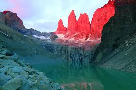
Torres del Paine National Park is one of the most spectacular national parks in the country. A world biosphere reserve, it has a huge variety of plant and animal species which, with its incredibly beautiful setting has made it an almost unequalled destination for hikers and backpackers, ecology-lovers and adventure sportsmen alike. Snow-capped mountain peaks, cascading rivers and waterfalls, glaciers and mirrored lakes: in all respects Torres del Paine national park deserves its reputation. Declared a biosphere reserve by UNESCO in 1978, the Torres del Paine national park (situated in the Magallanes 12th region in Chile) is internationally recognized as one of the most beautiful, unique and uncontaminated places on the planet.

It is a place of lakes, rivers, waterfalls, glaciers, forests and incredible wildlife, all of which make it an exciting destination for wildlife observers and adventure sportsmen alike. At the Southern tip of the Andes in Chile lies Torres del Paine National Park, one of the most impressive sights in the Southern Hemisphere and home to some of the world’s most classic trekking routes. The park is located in Chile’s southernmost and largest region, Magellanes and Chilean Antarctica, where the main economic activities are sheep farming, oil extraction and tourism. The population density is sparse at 1.1 per km² but the region’s main city Punta Arenas is home to 120,000 people. The park encompasses ancient forests, glaciers, lakes, rivers and fjords, and fauna including guanacos, foxes, pumas and a diverse array of birds. The park draws in approximately 100,000 visitors each year who visit the Paine Towers, Los Cuernos, French Valley and Grey Glacier. The W Trek and the Paine Circuit are popular routes. The park’s coordinates are 50°S latitude and 73°W longitude.

Natural Heritage in Torres del Paine National Park

Geomorphology: The landscape of the National Park is owed to earth movements which occurred 12 million years ago, and gave birth to its incredible peaks such as el Monte Paine Grande (3.050msnm) Los Cuernos del Paine (2.600, 2.400, 2.200 msnm) Torres del Paine (2250, 2460 and 2500 msnm,) Fortaleza, (2800), Escudo (2700 msnm.) Some of these have with permanent glaciers. Hydrography: Due to the vicinity of the southern ice sheet, the park has innumerable lakes, lagoons and rivers that owe their formation to the melting of the glaciers of which they are a part. Of the lakes stand out the Sarmiento, Nordenskjold, Pehoe de Grey, Paine and Dickson and there are also many lagoons of various sizes. The biggest rivers are the Pingo, Paine, Serrano and Grey.


The Paine is the most important (which originates in Lake Dickson, extreme north) and borders the massif of the east, crossing various lakes, and finishing by flowing into the Toro lake, in the extreme south of the reserve. On its route, the river plunges down three spectacular waterfalls: Paine, Salto Grande and Salto Chico. Flora: Inside the park at the Porteria Sarmiento we can find species that have their origin in desert environments, like the mata varrosa, the mata negra, the senecio and the calafate amongst the flowering plants, the estepa and coiron amongst the herbaceous. Now, inside the park, you can find small copses of lengua associated with herbaceous species like pasto ovillo, trebol and some flowering plants of great beauty like the capachitos and orchids which can be found again at the Laguna Azul and the Laguna Amarga. Fauna: Of the wildlife, it is the guanacos that receive most visitors and they are found in the vicinity of the Porteria Sarmiento.


However, it is also possible to see aquatic birds from the viewpoint in the Sede administration, where we see species such as cisne de cuello negro, pimpollo, tagua and huala, amongst others. Lesser rhea (ñandues) with their young can be observed inside the park, around Laguna Azul and the Sede Adminstrativa, and condors, can be observed close to the Pehoe ranger station. Inside the forest (the Lago Grey trail) we can find catitas, woodpeckers, austral blackbirds, long tailed meadowlarks, great horned owl and cometocinos.
Hiii Everyone,
                    I got some information about Swiss National Park. National Park Centre · Opening times . The Swiss National Park (German: Schweizerischer Nationalpark; French: ... As of 2009, it is the only National Park in Switzerland. Everything is nature-oriented in the Swiss National Park in the Engadine. All this can be enjoyed in an area of over 170 square kilometers. 


                    Swiss National Park

The Swiss National Park is unequalled in terms of the alpine scenery it offers across its 50mi (80km) of hiking paths and nature trails. Founded in 1914, Swiss National Park was one of the first national parks in Europe, and to this day remains Switzerland’s only national park. Understandably, the major activities within the park are hiking and observing wildlife. Thanks to the strict conservation rules in place, visitors are prohibited from veering off the marked footpaths, allowing a plethora of wildlife to be seen in an unspoiled environment.A variety of accommodation options are available within/near to the Swiss National Park. If you are hoping to stay within the park itself, you can stay in the famed Chamanna Cluozza (mountain hut) or the Hotel Parc Naziunal Il Fuorn.

The Chamanna Cluozza is a log cabin built at an altitude of 6175ft (1882m) in 1910. It provides rather basic accommodation, with toilets and washrooms, but no showers, and typically remains open from June until mid-October. The Hotel Parc Naziunal Il Fuorn is the only hotel within the park, and provides a few more creature comforts. Alternatively, the nearby Zernez serves as a gateway to the national park, and along with the parks official visitor centre, has a variety of hotels for guests to choose from.
The easiest and often fastest way to get to the Swiss National Park is by taking a train from Zurich to Zernez (2.5 hours one way), and then taking a postal bus service into the park. Timetables can be found here. When road and traffic conditions are perfect, driving takes a similar length of time (2.5 hours), though delays/traffic jams are commonplace, particularly during the winter months.


A single road runs throughout the national park, known as ‘Pass dal Fuorn’. Whilst this road is open for public use, public transport in the form of the postal bus is highly recommended. There are nine parking lots along this route, as well as numerous bus stops providing access to the parks many trails. The road gets busy, and is rather narrow, so pedestrian use is discouraged.